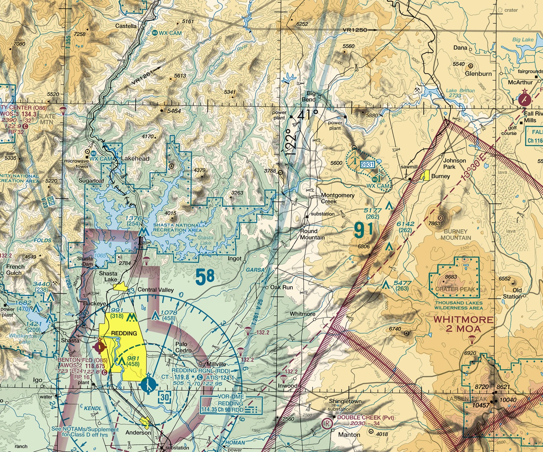
A real FAA VFR sectional chart excerpt — tap any symbol to identify it.
Un extracto real de una carta seccional VFR de la FAA — toca cualquier símbolo para identificarlo.
Explain the purpose and scale of a sectional aeronautical chart, and identify the basic categories of information it depicts: airports, airspace boundaries, obstacles, terrain, and navigation aids.
A sectional chart packs an enormous amount of safety-critical information into a single page using a precise visual language — learning to read that language is a foundational skill for both real cross-country flight planning and the FAA knowledge tests, which both draw heavily on real sectional chart excerpts.
Teach It / Enséñalo
ENTIENDE
Una carta seccional aeronáutica es la herramienta principal para la navegación VFR (visual) en los Estados Unidos, publicada a una escala de 1:500,000. Las cartas están etiquetadas con líneas de LATITUD y líneas de LONGITUD — juntas, la latitud y la longitud permiten describir cualquier ubicación con precisión mediante una coordenada. Los símbolos de AEROPUERTO en una carta seccional varían según las características del aeropuerto. Los LÍMITES DE ESPACIO AÉREO se muestran usando estilos de línea y colores específicos — azul sólido para Clase B, magenta sólido para Clase C, azul discontinuo para Clase D. Los OBSTÁCULOS se marcan con símbolos específicos que muestran su altura. El TERRENO se representa usando sombreado de color y cifras de elevación específicas, incluyendo las CIFRAS DE ELEVACIÓN MÁXIMA — la elevación más alta dentro de un cuadrado de cuadrícula específico de la carta. Las AYUDAS A LA NAVEGACIÓN, especialmente las estaciones VOR, se muestran con sus propios símbolos distintivos junto con información de frecuencia e identificación.
PIÉNSALO ASÍ
Piensa en un mapa de metro: no muestra cada calle de la ciudad, solo la información que necesitas para viajar de forma segura — las líneas, las estaciones, dónde cambiar de línea. Una carta seccional funciona igual, pero para volar: no intenta mostrar todo el terreno con detalle fotográfico, sino la información que un piloto realmente necesita para navegar y mantenerse seguro — aeropuertos, límites de espacio aéreo, obstáculos, y elevaciones del terreno — usando colores y símbolos estandarizados para que se pueda leer rápido, incluso bajo presión.
¿Tiene sentido?
AVIATION WORDS · Palabras de aviación
YOU MAY HEAR · Es posible que escuches
DILO EN INGLÉS · SAY IT IN ENGLISH
“A sectional chart shows airports, airspace, terrain, and obstacles using a standardized set of colors and symbols so a pilot can plan a safe route just by reading the chart.”
Ejemplo guiado
Consider a pilot planning a flight who notices a Maximum Elevation Figure of "9,800" printed in a chart grid square along their route: this tells them the highest terrain or obstacle in that entire grid square is at or below 9,800 feet MSL (the figure is deliberately rounded up for a safety margin), so planning a cruising altitude meaningfully above that figure provides real terrain clearance through that specific area — a direct, practical use of a chart symbol most students initially just memorize without connecting to real flight planning.
Real Aviation Application / Aplicación real en aviación
Real cross-country flight planning starts with spreading out the relevant sectional chart(s) and tracing the intended route, checking exactly what airspace, terrain, and obstacles lie along the way — this app's own Practice tracks and this lesson give the vocabulary and symbol knowledge; the physical or digital chart itself is where a student should practice applying it to a real route.
Ask Your Teacher / Pregúntale a tu maestro
- Can we look at a real sectional chart excerpt together and identify these features?
- How often are sectional charts updated, and why does that matter?
- What's the difference between a sectional chart and a Terminal Area Chart?
Practice Responding
What kinds of information does a sectional chart show, and why does it use standardized colors and symbols?
HAMPTON'S .02 CENTS
This lesson intentionally covers the chart's vocabulary and logic first; a genuinely interactive, tap-to-explore sectional chart tool (matching real, legally usable FAA chart data) is a larger feature this app doesn't have yet — see ROADMAP.md. Until then, pairing this lesson with an actual paper or digital sectional chart in class is the most effective way to make the content concrete.
Standards Alignment
CLASSROOM: Sectional Chart Reading
FAA: FAA Aeronautical Chart User's Guide
CERTIFICATION: Private Pilot, Part 107
SOURCES: Aeronautical Chart User's Guide