Obstacles and Terrain: Reading Elevation Data
Obstáculos y terreno: cómo leer los datos de elevación
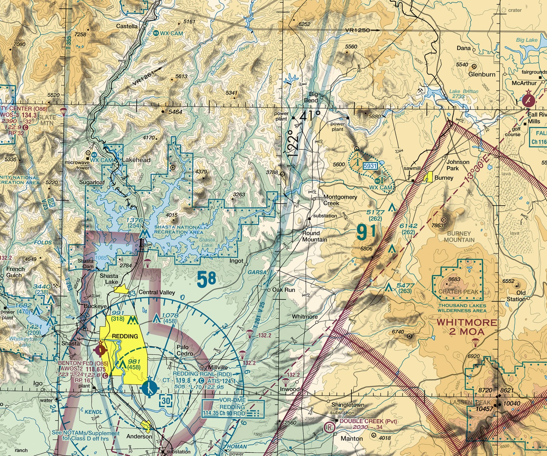
Real obstruction and terrain elevation symbols on the Klamath Falls sectional chart.
Símbolos reales de obstáculos y elevación del terreno en la carta seccional de Klamath Falls.
Read an obstruction symbol's height figures, distinguish a single obstruction from a group obstruction, and explain how a Maximum Elevation Figure is built from real terrain and obstacle data with a safety margin.
A tower a pilot never sees out the window because of haze, distance, or a moment of distraction is exactly the kind of hazard a chart is designed to warn about well before the flight — reading obstacle and terrain data correctly is a direct, practical defense against controlled flight into an obstruction.
Teach It / Enséñalo
ENTIENDE
Los SÍMBOLOS DE OBSTÁCULOS marcan torres, edificios altos, y peligros similares hechos por el hombre para el vuelo. Un solo obstáculo usa una forma de símbolo; varios obstáculos juntos usan un símbolo de obstáculo de grupo distinto. Junto a la mayoría de los símbolos de obstáculos aparecen dos cifras de altura: un número da la altura del obstáculo sobre MSL (nivel medio del mar), y un segundo número, a menudo entre paréntesis, da su altura AGL (sobre el nivel del suelo). El TERRENO se muestra usando sombreado de color — bandas de color correspondientes a rangos de elevación. Las líneas de contorno agregan más precisión dentro de esas bandas de color donde el relieve del terreno es significativo. La CIFRA DE ELEVACIÓN MÁXIMA (MEF), impresa en cada cuadrante de la carta, combina datos de obstáculos y terreno en un número conservador: refleja la característica más alta conocida dentro de ese cuadrante, con un margen de seguridad agregado, y luego redondeada HACIA ARRIBA al siguiente incremento completo de 100 pies.
¿Tiene sentido?
AVIATION WORDS · Palabras de aviación
DILO EN INGLÉS · SAY IT IN ENGLISH
“Obstacle symbols show both the obstruction's height above sea level and its height above the ground, and the Maximum Elevation Figure for each chart square gives you a safe minimum altitude reference that already includes a safety margin.”
Ejemplo guiado
An obstruction symbol shows the figures "1250" above "(450)" in parentheses. This tells a pilot: the obstruction's top is at 1,250 feet MSL, and it stands 450 feet above the surrounding ground. A pilot flying at 2,000 feet MSL in that area can quickly confirm they're clearing this specific obstruction by roughly 750 feet — a direct, practical use of both figures together.
Real Aviation Application / Aplicación real en aviación
Checking obstacle heights and the MEF for each grid square along a planned route is a real, standard part of cross-country flight planning — especially over unfamiliar terrain or in hazy conditions where a tower or ridge line might not be visually obvious until dangerously close.
Ask Your Teacher / Pregúntale a tu maestro
- How does a chart show an obstacle that's currently under construction?
- Are all real obstacles guaranteed to be charted, or can some be missing from the current chart edition?
- How much of a safety margin should a pilot personally add above the MEF, beyond what's already built in?
HAMPTON'S .02 CENTS
Students sometimes assume MSL and AGL are interchangeable since both measure 'height.' A quick, concrete drill — given an obstruction's MSL figure and the surrounding terrain's approximate elevation, have students calculate the AGL figure themselves — makes the distinction stick much faster than definitions alone.
It Would Behoove You… Continue to the next lesson: how each airspace class is actually drawn on the chart.
Standards Alignment
CLASSROOM: Sectional Chart Reading — Obstacles and Terrain
FAA: FAA Aeronautical Chart User's Guide
CERTIFICATION: Private Pilot, Part 107
SOURCES: Aeronautical Chart User's Guide