Airport Symbols and Data Blocks in Depth
Símbolos de aeropuertos y bloques de datos en profundidad
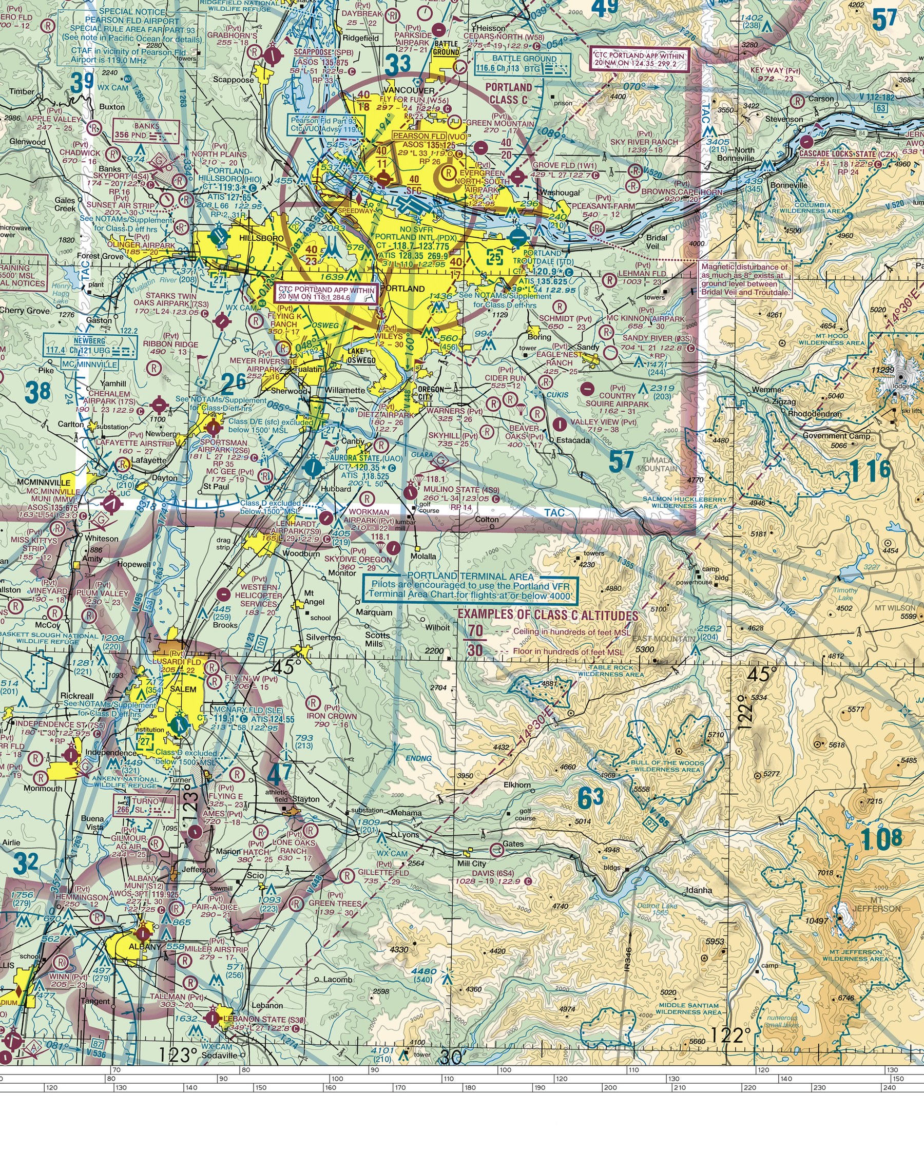
Real airport symbols on the Seattle sectional chart — tap one to identify it.
Símbolos reales de aeropuertos en la carta seccional de Seattle — toca uno para identificarlo.
Distinguish a towered airport's symbol from a non-towered airport's symbol on a sectional chart, and extract elevation, runway length, and lighting information from a real airport data block.
A pilot deciding whether to expect radio contact with a control tower, whether a runway is long enough for their aircraft, and whether the field has lighting for a return after dark can answer all three questions from the airport symbol and its data block alone — before ever calling the airport or checking a separate source.
Teach It / Enséñalo
ENTIENDE
Las cartas seccionales usan el color para responder una de las primeras preguntas que un piloto necesita sobre un aeropuerto desconocido: ¿hay una torre de control aquí? Un símbolo de aeropuerto impreso en AZUL indica que el aeropuerto tiene una torre de control operativa; un símbolo impreso en MAGENTA indica que no la tiene. La FORMA del símbolo también lleva información. Un aeropuerto con al menos una pista de superficie dura de 1,500 pies o más se dibuja con un símbolo que refleja su diseño real de pista. Junto al símbolo, el BLOQUE DE DATOS DEL AEROPUERTO incluye información específica real: el nombre del aeropuerto y su identificador, su ELEVACIÓN en pies MSL (impresa en negrita), la longitud de su pista más larga en cientos de pies, y un indicador de ILUMINACIÓN disponible (comúnmente una "L"). Un pequeño símbolo similar a una estrella cerca de un aeropuerto también indica que hay un faro giratorio o intermitente en funcionamiento.
¿Tiene sentido?
AVIATION WORDS · Palabras de aviación
DILO EN INGLÉS · SAY IT IN ENGLISH
“A blue airport symbol means there's a control tower; magenta means there isn't — and the data block next to the symbol gives you the airport's elevation, longest runway length, and whether it has lighting.”
Ejemplo guiado
A pilot planning a flight sees a magenta airport symbol with a data block showing an elevation of 1,200 and a runway-length figure of 42 (4,200 feet). Before making a single radio call, the pilot already knows: no control tower to expect (magenta), the field sits at 1,200 feet MSL (relevant for density altitude planning), and the longest runway is 4,200 feet — enough to start judging whether their aircraft's typical landing distance fits comfortably.
Real Aviation Application / Aplicación real en aviación
Real preflight planning includes scanning the data blocks of the departure airport, any planned fuel or rest stops, and the destination — checking elevation (for density altitude), runway length (for performance planning), and lighting (in case of a delayed or after-dark arrival) directly from the chart, well before ever needing to call ahead.
Ask Your Teacher / Pregúntale a tu maestro
- How can I tell from the chart alone whether an airport has fuel available?
- What does it mean if an airport symbol has no runway extensions drawn at all?
- How current does an airport's charted data block stay between chart publication cycles?
HAMPTON'S .02 CENTS
The blue/magenta color convention is one of the highest-value, fastest-to-teach facts in this entire unit — it's worth a rapid-fire drill showing several airport symbols in isolation (no data block) and having students call out towered vs. non-towered from color alone, since that recognition needs to become instant.
It Would Behoove You… Continue to the next lesson: Obstacles and Terrain, covering how elevation hazards are marked on the same chart.
Standards Alignment
CLASSROOM: Sectional Chart Reading — Airport Symbols
FAA: FAA Aeronautical Chart User's Guide
CERTIFICATION: Private Pilot, Part 107
SOURCES: Aeronautical Chart User's Guide